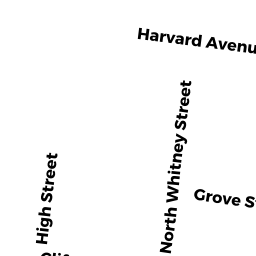
124 NORTH WHITNEY ST
Owner Information
LA COUR, NIELS PIERRE & SARAH COLLINS
124 NORTH WHITNEY ST
AMHERST, MA 01002


Property Details
124 NORTH WHITNEY ST is classified as a Single Family Residential (Farmhouse).
The primary structure on this property was built in 1910. There are 3,144ft2 of built area within this property. There is 2,208ft2 of residential/living space within this property. This property is listed as having 8 rooms.
124 NORTH WHITNEY ST is valued at $389,600. The land is valued at $158,700 and the structures are valued at $227,400. There is an additional valuation of $3,500 on this property.
This property is in Zone RG10. Confirm with local Zoning Board authorities to ensure there are no overlays or other easements on this property.
The most recent deed for 124 NORTH WHITNEY ST is recorded at the local registrar in Book 5421, Page 0114. 124 NORTH WHITNEY ST was last sold on Thursday, July 2, 1998 for $145,000.
Assessment data from fiscal year 2022.
Flood Data
According to the FEMA National Flood Hazard Layer, this property does not appear to be in a flood zone. It may also be in an area not yet reviewed. Nonetheless, confirm this information prior to taking any action.
To view the flood hazards around this property, create a FEMA "Firmette" Map of the area around 124 NORTH WHITNEY ST.
Broadband Internet Providers
| Provider | Type | Bandwidth (mbps) | |
|---|---|---|---|
| Comcast | Cable | 1000 | 35 |
| Viasat Inc | Satellite | 100 | 3 |
| Verizon New England Inc. | DSL | 7 | 0 |
| GCI Communication Corp. | Satellite | 0 | 0 |
| HughesNet | Satellite | 25 | 3 |
| VSAT Systems, LLC. | Satellite | 2 | 1 |
Broadband service provider data from December 2020.
Adjacent Properties
- 118 NORTH WHITNEY ST
Single Family Residential owned by CLEVENGER, DAVID & CLEVENGER, PAUL - 19 HARVARD AVE
Single Family Residential owned by DOWD, KIMBERLY A - 129 HIGH ST
Single Family Residential owned by PREMILA NAIR - 7 HARVARD AVE
Single Family Residential owned by TRIPP, TODD M & WAITE, SUSAN M - 119 HIGH ST
Two-Family Residential owned by POPE, CAROL C